Moidart, Sunart & Ardgour 2007
Click on pictures to access the full album (321 photos)
Saturday 07 April 2007
 For
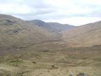
this walk I decided to visit the remote and relatively unknown peninsular
areas of Moidart, Sunart and Ardgour, going from Lochailort to Fort William.
For
this walk I decided to visit the remote and relatively unknown peninsular
areas of Moidart, Sunart and Ardgour, going from Lochailort to Fort William.
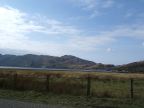
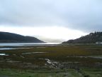
After getting a lift from
the NTS minibus as far as Lochailort, I could start my walk around 1500 with
a local tour of Inverailort with its fish farm, to start climbing the path
behind Tom Odhar, which soon arrived on a quad track winding up the glen.
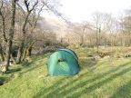
A couple of walkers came down from the misty tops, but I continued upwards
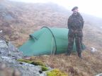
until finding a nice pitch at NM7719 7910, with an elevation of 350m. A
good place to set up camp, having an oatmeal dinner (my staple food in the
hills) and a nice sleep in this lonely glen. This introductory walk of 7
km was performed at an average walking speed of 3,3 km/h.
Saturday's walk on Google Earth (Save this file to your disk and open in google Earth)
Sunday 08 April 2007
 A nice but cloudy morning, and setting on at 0930 after
an oatmeal/chocolate breakfast for the rest of the climb. First to the small
bealach over Coire na Cnamha to catch a last glimpse of the sea and the islands,
and then up to the Bealach an Fhiona, 701m elevation, a very difficult bit
along the steep and rocky north face of Rois Bheinn, awkward terrain with
lots of loose rocks. The bealach was eventually reached around 1300, time
to mark a pause and to enjoy my last can of Export! Some walkers passed the
bealach, on an east-west walk doing the Corbetts. I went south however, descending
into Glen Moidart along te south slopes, which were smooth and grassy but
quite steep and no path, so that it took nearly two hours to descend 600m
to reach the ruined settlement of Assary.
A nice but cloudy morning, and setting on at 0930 after
an oatmeal/chocolate breakfast for the rest of the climb. First to the small
bealach over Coire na Cnamha to catch a last glimpse of the sea and the islands,
and then up to the Bealach an Fhiona, 701m elevation, a very difficult bit
along the steep and rocky north face of Rois Bheinn, awkward terrain with
lots of loose rocks. The bealach was eventually reached around 1300, time
to mark a pause and to enjoy my last can of Export! Some walkers passed the
bealach, on an east-west walk doing the Corbetts. I went south however, descending
into Glen Moidart along te south slopes, which were smooth and grassy but
quite steep and no path, so that it took nearly two hours to descend 600m
to reach the ruined settlement of Assary.
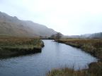 Time
for an oxo break there! It started raining however, and I got forward through
boggy Glen Moidart on the quad track which was in places improved with (slippery)
wooden planks. I continued down to the gates of Glenmoidart house gardens
which were closed - so far for open access land. I had to circumvent the
fence plodding down a very bad bog to the river, and then further on to cross
the river Moidart on a very rickety bridge. This brought me on the road which
I followed just a bit before taking another path south in the direction of
Loch Shiel. I set up camp in a desolate moor close to Torr a Bhreitheimh,
NM 7340 7023, having walked 13,4 km at an average speed of just 2,2 km/h.
A bad, uneven pitch, not much clear water around here (just brown moorwater)
and wind and rain all night.
Time
for an oxo break there! It started raining however, and I got forward through
boggy Glen Moidart on the quad track which was in places improved with (slippery)
wooden planks. I continued down to the gates of Glenmoidart house gardens
which were closed - so far for open access land. I had to circumvent the
fence plodding down a very bad bog to the river, and then further on to cross
the river Moidart on a very rickety bridge. This brought me on the road which
I followed just a bit before taking another path south in the direction of
Loch Shiel. I set up camp in a desolate moor close to Torr a Bhreitheimh,
NM 7340 7023, having walked 13,4 km at an average speed of just 2,2 km/h.
A bad, uneven pitch, not much clear water around here (just brown moorwater)
and wind and rain all night.
Sunday's walk on Google Earth (Save this file to your disk and open in google Earth)
Monday 09 April 2007
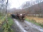
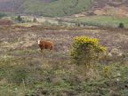
 Up early at 0730 and through at 0845 in the rain to the
shores of Loch Shiel. A lot of cattle on the track, often difficult to circumvent,
at one case they even blocked the gate! By 1000 I had reached hard road for
the rest of the day. The Clanranald Inn was still closed as I went by, so
on to Acharacle where I stopped for fish and chips and further to Salen for
a couple of pints in the Salen Inn. This left just 4 km of walking to the
excellent Resipole campground (NM7221 6400), where I pitched at 1530 and
could enjoy the benefit of a hot shower. After the oatmeal supper I headed
the 4 km back to Salen for another visit to the pub, and 4 km back afterwards.
Total walking today of 25,4 km, with a good average of 4,7 km/h.
Up early at 0730 and through at 0845 in the rain to the
shores of Loch Shiel. A lot of cattle on the track, often difficult to circumvent,
at one case they even blocked the gate! By 1000 I had reached hard road for
the rest of the day. The Clanranald Inn was still closed as I went by, so
on to Acharacle where I stopped for fish and chips and further to Salen for
a couple of pints in the Salen Inn. This left just 4 km of walking to the
excellent Resipole campground (NM7221 6400), where I pitched at 1530 and
could enjoy the benefit of a hot shower. After the oatmeal supper I headed
the 4 km back to Salen for another visit to the pub, and 4 km back afterwards.
Total walking today of 25,4 km, with a good average of 4,7 km/h.
Monday's walk on Google Earth (Save this file to your disk and open in google Earth)
Tuesday 10 April 2007
 A
cloudy morning with low mist hanging over the Ben Resipol range and bad visibility,
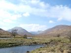
so I decided to take the road walk to Strontian. It might be an A road (A861)
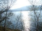
but it is single track with very low traffic and there are nice views over
Loch Sunart. Arrived Strontian in the early afternoon and set camp at the
small but cozy Glenview campsite (NM8165 6186), followed by an afternoon
walk in the hills around Strontian.
A
cloudy morning with low mist hanging over the Ben Resipol range and bad visibility,
so I decided to take the road walk to Strontian. It might be an A road (A861)
but it is single track with very low traffic and there are nice views over
Loch Sunart. Arrived Strontian in the early afternoon and set camp at the
small but cozy Glenview campsite (NM8165 6186), followed by an afternoon
walk in the hills around Strontian.
Total distance today: 25,3 km at 4,6
km/h average.
Tuesday's walk on Google Earth (Save this file to your disk and open in google Earth)
Wednesday 11 April 2007
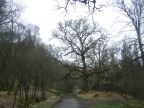
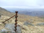
 Made
it an easy morning, got baked beans for breakfast from the Strontian shop
and got on around 1000 to the Ariundle forest for a nice walk to the Fee
Donald lead mine site where I spent some time for lunch looking at the very
interesting remains on site. Further east, off-path, towards the Bealach
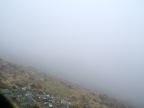
Mam a Bhearna. Thick fog set in however, with a visibility under 100 ft and
slow advance on the steep and difficult south slope of Druim Leac a Sgiathain.
Made
it an easy morning, got baked beans for breakfast from the Strontian shop
and got on around 1000 to the Ariundle forest for a nice walk to the Fee
Donald lead mine site where I spent some time for lunch looking at the very
interesting remains on site. Further east, off-path, towards the Bealach
Mam a Bhearna. Thick fog set in however, with a visibility under 100 ft and
slow advance on the steep and difficult south slope of Druim Leac a Sgiathain.
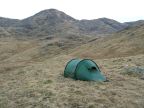
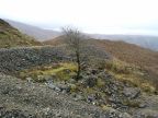
 There
was no path, so one had to follow the sheep and deer paths, mainly recognisable
by the droppings! It took nearly three hours over rough terrain to cover
three grid squares to the bealach area, where there were at last some flat
areas for a good pitch. A very nice spot was found at NM8843 6659, elevation
500m: flat, dry grass, a clear spring nearby. An eerie place in the mist
however, which cleared briefly at sunset allowing a glimpse of Loch Sunart,
but fell in again quickly, for a very cold and wet night. No problem however
in a warm sleeping bag! Today covered 11,2 km at 3,0 km/h average.
There
was no path, so one had to follow the sheep and deer paths, mainly recognisable
by the droppings! It took nearly three hours over rough terrain to cover
three grid squares to the bealach area, where there were at last some flat
areas for a good pitch. A very nice spot was found at NM8843 6659, elevation
500m: flat, dry grass, a clear spring nearby. An eerie place in the mist
however, which cleared briefly at sunset allowing a glimpse of Loch Sunart,
but fell in again quickly, for a very cold and wet night. No problem however
in a warm sleeping bag! Today covered 11,2 km at 3,0 km/h average.
Wednesday's walk on Google Earth (Save this file to your disk and open in google Earth)
Thursday 12 April 2007
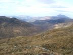
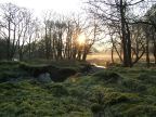
 A clear morning without any fog, which rewarded me with
a broad view on Strontian, Loch Sunart, Ben Resipol and the Morvern hills!
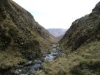
A short walk down to the Bealach Mam a Bhearna, and then the descent into
Glen Mhic Phail, leaving Sunart for Ardgour. The descent is quite adventurous
as the upper part of the glen forms a narrow gorge with steep slopes. I thought
it more sensible to follow the burn on the bottom, this necessitated however
several fordings and some scrambling. The lower part of the gorge was less
steep and could be negotiated on the easy but boggy slopes. Passed the gorge,
a path soon appeared and the sun set in when I reached Glen Scaddle.
A clear morning without any fog, which rewarded me with
a broad view on Strontian, Loch Sunart, Ben Resipol and the Morvern hills!
A short walk down to the Bealach Mam a Bhearna, and then the descent into
Glen Mhic Phail, leaving Sunart for Ardgour. The descent is quite adventurous
as the upper part of the glen forms a narrow gorge with steep slopes. I thought
it more sensible to follow the burn on the bottom, this necessitated however
several fordings and some scrambling. The lower part of the gorge was less
steep and could be negotiated on the easy but boggy slopes. Passed the gorge,
a path soon appeared and the sun set in when I reached Glen Scaddle.
 Good
weather for the walk through this long and lonely glen (not one soul in sight
for the whole day), past the stalker's bothy at Tighnacomaire and then the
forest track, up to the ruined cottages of Creagbheiteachain. A bit further,
I spotted a wonderful camping spot near the river at NM9920 6841. Sitting
out in the sunshine and having a tea, don't even think about it in summer!
I had a last oatmeal supper, and then the last tea because the gas ran out!
A small cartridge proved to be just enough for a week, a bit on the short
side even; a big one would have been way too much. Other supplies also were
running down; I had to change batteries on my camera and GPS earlier in the
day, and even my tin of shoeshine got to an end! Headlight batteries however
just seem to last forever.
Good
weather for the walk through this long and lonely glen (not one soul in sight
for the whole day), past the stalker's bothy at Tighnacomaire and then the
forest track, up to the ruined cottages of Creagbheiteachain. A bit further,
I spotted a wonderful camping spot near the river at NM9920 6841. Sitting
out in the sunshine and having a tea, don't even think about it in summer!
I had a last oatmeal supper, and then the last tea because the gas ran out!
A small cartridge proved to be just enough for a week, a bit on the short
side even; a big one would have been way too much. Other supplies also were
running down; I had to change batteries on my camera and GPS earlier in the
day, and even my tin of shoeshine got to an end! Headlight batteries however
just seem to last forever.
All set now for the last bit tomorrow morning, a final quiet night in the
Nammatj. Today I walked 14,9 km with an average of 3,1 km/h.
Thursday's walk on Google Earth (Save this file to your disk and open in google Earth)
Friday 13 April 2007
 Get
up early and assemble for the final leg: a quiet road walk along the shores
of Loch Linnhe to Camusnagaul, under a bright sunshine, where I arrived about
1120, well in time for the wee ferry to Fort William an hour later, bringing
an end to this magnificent trip. This was all track and road walking, so
I covered the 14,6 km with a 5,1 km/h average. Such good speeds on road,
even with a heavy bag (around 24 kg - see my packlist), are feasible thanks
to my little friend the iPod Shuffle.
With some tunes of good rhythm (see my playlist)
it keeps you in the mood, it has a good autonomy and can be charged several
times from a charged Solio.
Get
up early and assemble for the final leg: a quiet road walk along the shores
of Loch Linnhe to Camusnagaul, under a bright sunshine, where I arrived about
1120, well in time for the wee ferry to Fort William an hour later, bringing
an end to this magnificent trip. This was all track and road walking, so
I covered the 14,6 km with a 5,1 km/h average. Such good speeds on road,
even with a heavy bag (around 24 kg - see my packlist), are feasible thanks
to my little friend the iPod Shuffle.
With some tunes of good rhythm (see my playlist)
it keeps you in the mood, it has a good autonomy and can be charged several
times from a charged Solio.
This ended a nice 112 km (70 mile) walk through a beautiful and remote area!
Friday's walk on Google Earth (Save this file to your disk and open in google Earth)
Note: all grid references, distances, track logs and average speeds were obtained from my GPS device (Garmin GPSmap60), the average speed only taking into account actual walking time - a good thing so that a break in the pub does not botch your average!
Main page
Photo Album
All pictures © LHOON and available under Creative Commons license
